Beautiful Banff National Park – What is There to See?

Disclaimer: This blog contains affiliate links meaning I earn a small percentage of every purchase at no cost to you.

The Canadian Rockies is the most famous landmark in Canada. Also, they are what most people come to Canada to see. I can understand why. This was simply nature, at its best. Personally, I love nature and there was just so much to see here in Banff National Park. Again, we are road tripping so, therefore, visiting places at our own pace. I highly recommend hiring a car as it is the easiest way to see everything.

Highway 1A – A Scenic Drive Through Banff National Park

There is the quick and main highway 1 that runs through Banff National Park. However, the best option for tourists is to take the more scenic Highway 1A. Highway 1A is also known as Bow Valley Parkway. The chances are higher to spot bears and wildlife. Remember to stay far away as possible and do not feed wild animals.

Lake Minnewanka, Banff National Park
Lake Minnewanka

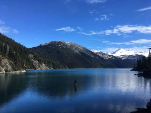
Lake Minnewanka – A Glacier Fed Lake in Banff National Park

Arriving at Lake Minnewanka early in the morning was very pleasant. The sound of nature ringing out rather than the hustle and bustle of the tourists. Lake Minnewanka is a short 5 km drive from the town of Banff. This lake is impressive in size as it stretches over 21 km. Signs signalled that there was a bear active in the area. This meant that you are advised to travel in a group of 4. Unfortunately, we were a pair, therefore, no early morning hike for us. Plus, we left the bear spray in the van (again).

Lower Falls At Johnstone Canyon
Lower Falls

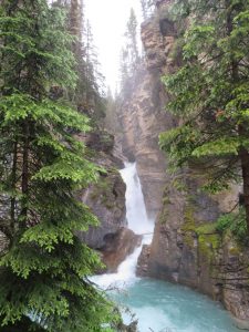
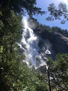
Johnstone Canyon and The Ink Pots – A Banff National Park Hike

To beat the tourists, it is best to go to all places early morning. Banff National Park is the reason why people come to Canada. Therefore, you can only imagine how busy this place gets. Our early morning hike to Johnstone Canyon only had a couple of other people. This meant no queue for the Instagram shot.

Hole View of Johnstone Falls, Banff National Park
The Hole Viewpoint
Ink Pots at Johnstone Falls, Banff National Park
The Ink Pots at Johnstone Canyon

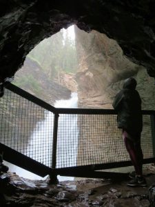
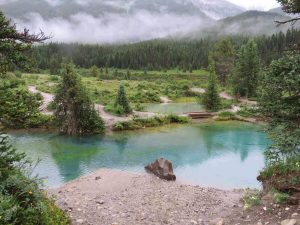
1.2 km to the lower falls and an extra 1.2 upper falls. This is where most people turn around and go back. We didn’t we continued further to get to the ink pots. The ink pots are a further 10.8 km from the trailhead. The ink pots are the water source for the falls. They are vibrant blue in colour, round in shape, and dotted all over the field. These are pretty and worth the extra trek. It had been raining the day before therefore after the paved trail it did become muddy and slippery in places. Be careful! We managed not to fall!! Result.

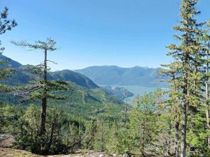
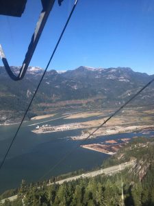
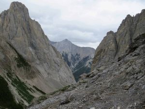
The Cory Pass – A 13 km Hike in Banff National Park

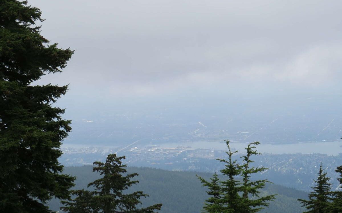
This hike was definitely my favourite for many reasons. It was 13km but very hard work. This is no easy hike especially for us as we aren’t experts. Although, we had more stamina than when we did the Grouse Grind. Yet, if this was our first hike of the trip… I wouldn’t have made it. Grouse Grind was easy compared to this.

The saying is the harder the work, the greater the rewards. This was no different. We hiked hard. The reward was what I think are the best views within Banff National Park. This trail starts at the Fireside Picnic area off Highway 1A.

The starting point of the hike

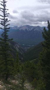
The total elevation for this hike was 1075 metres. The trail quickly gained 450 metres. This section was without a doubt the steepest. There were splendid views over the Bow River and Township of Banff. Wildflowers were surrounding the trail as it started to flatten, however, it was still up and down a bit.

After this section, we reached the rocky path which took us uphill again. This was the start of the second hardest section of the hike. It looked like the trail ended at a bottom of a rock. Yet, the only way was over, we had to scale the rock. We climbed over safely and started to hike along the rocky path.

The View From the Cory Pass Hike
The View A Little Way Up on The Cory Pass

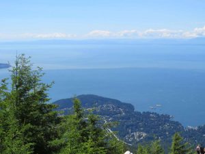
Taking in the 360 views

We took regular stops not just because we needed them; because you just have to take the time to appreciate the view.  There were spectacular views in every direction and the landscape changed so much in a short amount of time. You will not be disappointed. Nature is such a joy and Canada has so much of it.

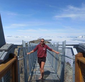
Reaching the top of the Mountain

Top of The Cory Pass Hike, Banff National Park
The Hard Work Paid Off As We Reached The Top

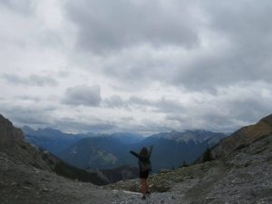
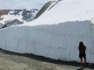
At the top 2350 metres above sea level, it was cold and windy. Patches of snow left the resemblance of Winter. A gentle reminder of how cold Canadian Winter can be. The sense of accomplishment was through the roof, never would I have thought I would hike a steep mountain. A quick lunch break because the wind was strong and cold. Then, we headed around the back of the mountain on stone cairns which slipped from under us as we trod carefully. This was home to some Mountain Sheep. They have hooves designed to walk on these, we had runners on.

The Cory Pass, Banff National Park
The Hike Around The Back of The Mountain Range

Next, was a forest path and with the trees lining either side the views soon disappeared. We tried to pick up our pace as it looked like rain could fall any minute. Therefore, before we knew it, we were back at the fork where we turned left in the morning. This meant 1km to go till we were back at the car park.

The Last Surprise on the Cory Pass

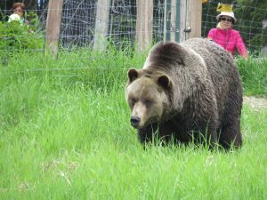
This hike had already delivered so much but it had one last surprise for me. As I looked along the trail there it was a big brown fluffy behind. The only place I had seen this before was Grouse Mountain. I turned back to my friend to tell her and grab the bear spray. A WILD GRIZZLY.

Mountain Goat Hiding from The Grizzly Bear
We Didn’t Get a Snap of The Grizzly Bear so
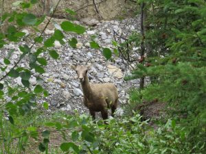
Here’s a Mountain Sheep

In that thirty seconds, the Grizzly Bear made its way off the trail and up slightly. And all you could see was his head in amongst flowers. He was happy. He had a food source. And lucky for us hadn’t noticed us. This was unbelievable and topped off the hike perfectly. It was scary and exciting all at the same time. The adrenaline rush from completing a difficult hike and seeing an incredible Grizzly in its natural habit was mind-blowing. A must-hike in Banff National Park.

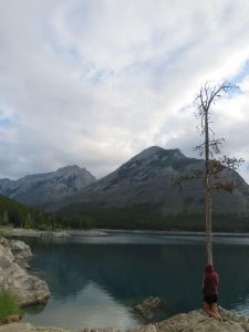
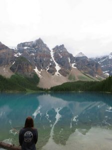
Lake Morriane – A Favourite

We visited Lake Morrianne in the evening expecting the crowds to be less. However, that was not the case. We managed to get a car parking space but only just. Luckily, someone was left as we arrived. A stroll along the shoreline to find the perfect dinner spot. Yes, dinner was glamorous tonight: ham rolls by the magnificent lake.

Lake Morriane, Banff National Park
Dinner at Lake Morriane

Lake Louise – Lake Anges to Big Beehive to Plain of 6 Glacier Hike

Sunrise Over Lake Louise, Banff National Park
What A Start To The Day A Beautiful Sunrise With Alpine-Glow

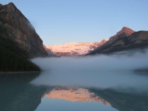
This day started with a magnificent sunrise over the most popular lake here in Banff, that’s right… Lake Louise. With snow still capping the Mountain Peaks that pink alpine glow was present as the sun rose. A treat to start the 20 km hike with. Firstly, we stopped by Lake Anges and the Teahouse. The teahouse served a good breakfast. Although it was very busy we were able to get seated straight away due to being one of the first there. So, it wasn’t long before we set off again.
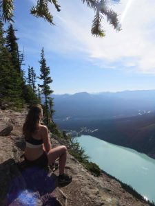
Big Beehive Lookout

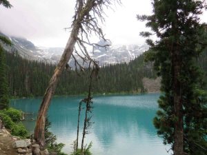
We slowly made our way up to the big beehive lookout. The route up was switchbacks that were steep! We made it in one piece, just with a lot of breaks. It was worth it; the wow factor was definitely here as I overlooked the incredible Lake Louise. The vibrant blue colour of this lake speaks for itself. A must-see.

Big Beehive Lookout Over Lake Louise
Big Beehive Lookout Point

Plain of 6 Glaciers

We made our way back down. It was downhill all the way. This was the moment the hike got tougher. Tougher because my sore legs had to carry me the rest of the way. Too many hikes in a short amount of time were affecting my body. I had to hobble down as my knee was too painful when doing the bending motion. This wasn’t the best situation but it wasn’t going to end my hike. Even though I had this small issue, I continued to the plain of six glaciers. This was relatively flat but still a further 4 km (roughly) there and back. Again, just like everything in Banff National Park the views were outstanding. Also, the sound of the ice breaking off the glaciers was ringing deep into the valley.

The Shoreline of Lake Louise

We could finally start to relax we were on the home straight. A nice stroll along Lake Louise shoreline. Sheltered in places away from the burning rays of the sun. The excitement and sense of accomplishment ran through us. I never thought I would ever hike over 20 km in one day but I did. I think I have found a new hobby… hiking. I am a fan; the hikes may be tough but the reward melts away all the moments that you think you can’t make it. Again, another must-hike in Banff National Park.

Summary of Banff National Park

Well, I am amazed and in awe, by all, I witnessed during my road trip through Banff National Park. I understand why the Canadian Rockies are the number one tourist attraction for people from all across the world. If the Canadian Rockies aren’t on the bucket list, add them, and you will be left speechless over and over again.

The Best National Park in Colombia – The Beautiful Tayrona

Disclaimer: This blog contains affiliate links meaning I earn a small percentage of every purchase at no cost to you.

Tayrona National Park is this beautiful haven sitting on the Caribbean coastline. It is covered with luxurious, tropical forests, secret trails, and some of the best beaches in Colombia. This little bit of paradise isn’t the cheapest place to visit and yes as tourism grows in Colombia this is one spot to put on your list.

Day One – Tayrona National Park: Hiking to Camp Cabo

Walking along the horse track at  Tayrona National Park
The Walk to Camp Cabo

As we started our adventure into the forest a bus is on offer to take you roughly 3km. You could choose to walk this but there isn’t much to look at. Also, there will still be a lot of hiking from the bus stop point anyway. The trails aren’t marked but were well-trodden in places. As we set off the temperature began to rise, and the humidity did too. Luckily most of this walk was under the canopy of the trees.

We walked as far as ‘Camp Cabo’, this is the beach Google shows you when searching for Tayrona. Somehow as we left the first camp to continue the hike, we ended up walking the horse track. It looked to be the only route. If you met us, you would know we always mess it up a little. There was less to look at but was much cooler.

Arriving at Camp Cabo…

Our arrival at Camp Cabo was breathtaking, we may have been hot and sweaty but the view was incredible. A pretty horseshoe bay with golden sand and blue waters gently lapping with a mountain backdrop covered in tropical trees. Now, I can see why this is the poster image of Tayrona National Park.

We booked our spot for the night, we chose the more expensive hammocks to sleep in. These were the ones up on the rocks that give you the view I just described. Now it was time to kick back and enjoy the beautiful weather and crystal-clear water. An afternoon at the beach, my favourite place.

Me relaxing in a hammock which was our bed for the night at Camp Cabo
Comfy Hammock Until The Rude Awakening

Feeling nice and relaxed we got into the hammocks and soon drifted off to sleep. What felt like as soon as my eyes shut; there was a thunderstorm. The rain lashed down and before I could get out of the hammock I was soaked. However, the storm was amazing to watch over the sea. The rumbles of thunder were deafening and the lightning was so bright it lit up the whole bay. As it passed over, the coldness of being soaked swept over my body. Sleep that night went a miss.

Day 2: Hiking Back to the Entrance

We packed extra light for this trip so we didn’t have to carry much so changing clothes wasn’t an option. Cold and damp from the magnificent tropical thunderstorm we set off. This time along the hiker’s path, not the horse track. We stopped off at ‘La Pisicina’ a cute little swimming beach. Swimming beaches are rare to find as the sea here has powerful currents that make entering the water too dangerous. An early morning swim is what we needed. The sun rose in the sky and we were soon warm again.

Me standing on a stone by the sea water at the beach at Tayrona National Park
The Beach Walk

This walk was much quicker than the horse track we accidentally took up to Camp Cabo. The walk was in the sun and along the beach. So much more to look at. However, us being… well us. Somehow again messed up and yep you guessed it… ended up on the horse track. We technically did the whole normal walk. Just some on the way there and some on the way back. The horse track was so muddy this time so we had to go barefoot. Fli–flops just kept getting stuck.

Summary of Tayrona National Park

This haven on the Caribbean coast is worth the visit but I would suggest more time to explore the area. As there are different trails throughout the park. All in all a nice, pleasant trip. I really enjoyed myself even getting woken by the storm. I would definitely go again. We packed in food with us to help keep the costs down. Unfortunately, compared to Iguazu or other attractions Tayrona isn’t cheap. It was easy to get to by the local bus from Santa Marta. Like all popular tourist attractions, early arrival is a must because only a certain amount of people get in per day. You don’t want to be disappointed. It’s worth it.

The Stunning Iguazu Falls – Which Side is the Best?

Disclaimer: This blog contains affiliate links meaning I earn a small percentage of every purchase at no cost to you.

Iguazu Falls. There is a debate among travellers as to which side to visit. Which side is the best? This question is answered with very mixed responses. Argentina some say. Brazil the others pop up with. We toyed with which side to go to. Argentina’s side had more to offer. Brazil is more landscape. The responses seemed all down to personal preference. With all opinions in mind, we had our decision.

We managed to easily access both sides by public transport but for those who would like a tour, there are many available with a much more comfortable bus ride!!

A Day at the Argentina Side of Iguazu Falls

Water rushing over the devils throat of Iguazu Falls
The Power Surge of The Devil Throat

Arriving early by bus and getting tickets at the gate was easy. However, crowds do quickly form hence the early start. I was excited, who doesn’t love a good waterfall? I love nature. If you have read any of my other blogs you will know being outdoors is where I like to be.

The weather was on our side today. Bonus. We opted to take the train all the way to the top as most people start at the first stop. The top of the waterfall is known as the devil’s throat and once in view, you understand why. This powerful surge of water fell in tremendous volume over the ledge at an impressive speed. All I could do was look on in awe.

The Easy to Follow Walkways

The metal boardwalk with a tree canopy at Iguazu Falls
The Walkways on The Argentina Side

There is a network of walkways taking you to different viewpoints throughout the park. Easy walks. Nothing too crazy. Well, the views are, that’s for sure. You are surrounded by spectacular views no matter which way you look. I can see why people say this side is best for them. Whilst maneuvering the walkways, we reached the upper part which came with views of many smaller waterfalls. The lower part took you right next to a smaller waterfall. Don’t be fooled by the word smaller they still raged and the spray hit you as you approached the end.

Summary of the Argentina Side of Iguazu Falls

The crowds were getting busier as the day went on. Nature is amazing and this is simply a masterpiece. I feel that you get a good feel for this waterfall because there are different perspectives throughout the park. I can see why people pick this as their favourite, it’s a really good day out. You get to see and hear the falls as well as spot wildlife.

A Day Trip to The Brazilian Side of Iguazu Falls

Me over-looking the Iguazu Falls on the Brazilian side
Enjoying the Brazilian Side

Yes, we chose both sides due to varying opinions. Also, we are only going to visit it once in our lifetime. Missing out wasn’t an option. I prefer ticking off the bucket list first before going back to places. This wasn’t as well put together as the Argentinian side. There was less walking and not so much wildlife. This doesn’t mean that the Brazilian side can’t stand up and make a name for itself because it does. This site offers something that you don’t get from the Argentina side. The panoramic view. Yes. All of the waterfalls in one eyeshot. Here, you see how big and expansive these waterfalls really are. As well as the amount of land that they cover and the size of the river that they flow into.

A full rainbow over the falls on the Brazilian side with trees as the backdrop
Perfection

Also, there is a little walking platform out to the devil’s throat. However, on this side of the Iguazu Falls, you get drenched from the fast-paced water pouring over. The shine from the sun and moisture from the water made for a beautiful rainbow. Perfect.

Summary of the Two Sides of Iguazu Waterfall

Overall, all the opinions we gathered were valid. The Argentina side had more on offer but the Brazil side had more panoramic. I, personally cannot pick between the two sides. My breath was taken away by both; due to both offering different perspectives of what is truly one magnificent waterfall. It is in the top three to see in the world and it’s very easy to see why. Whichever side you choose you will be speechless. If I did it all over again, I would still choose both.

The Best Stops on Scenic Sea to Sky Highway

Disclaimer: This blog contains affiliate links meaning I earn a small percentage of every purchase at no cost to you

The sea-to-sky highway is one of the most beautiful scenic drives. I have stopped by many of the places along the Sea to Sky Highway. However, at different times during my time in Whistler. Driving up this road excites me as I know it is the way to Whistler. I spent the winter there in 2018-19 and it couldn’t feel more like home even if it tried. Starting at sea level and rising 670 metres above in the mountains. The smooth road has many twists and turns as you make your way up. If you are West in Canada then this drive is a must.

Sea to Sky – Cypress Mountain

Cypress Mountain is another Mountain in Vancouver. It was highly recommended to me by a family member so it was a must-stop. We got there early as we planned to hike to the top. Yes, I hiked in flip-flops and this time they didn’t break. My favourite flip-flops are

Effie's Lookout over Horseshoe Bay from the peak of Cypress Mountain
Effie’s Lookout. A Nice Lunch Spot in the Sun

We weren’t tired or experiencing achy legs at the top so decided to hike on to Effie’s Lookout. What a good decision that was. The views over the whole of the bay were incredible. To top it off the sun was shining and not many clouds in the sky. Another winning view for lunch. Lastly, we stopped by Cabin Lake for a quick dip, very cold. Jumping straight in was definitely a shock to the system!!

The Stawamus Provincial Park – Shannon Falls

Shannon Falls falling over rocks on the Sea to Sky Highway
Shannon Falls at Squamish

As you continue up the beautiful Sea to Sky corridor you reach Shannon Falls. This can be a quick stop if you don’t do any of the hikes on offer. Shannon Falls is the third highest waterfall standing at 335 metres. The waterfall wasn’t full yet but it was still impressive.

The Stawamus Chief, Squamish

Squamish Chief hike is very well-known with locals and tourists alike. So being a resident in Whistler it was only fitting to attempt to get to the top. I was scared to complete this hike. Rumour has it, that you have to climb a ladder for a bit of it. This is a very tough hike; luckily we weren’t in a rush so that we could take our time. Time was definitely needed to complete this.

The viewpoint from the chief hike over a forest and the Howe Sound
The View From Stawamus Chief

Stawamus Chief is 700m tall and divided into Frist Peak, Second Peak, and Third Peak. The trail starts at Shannon Falls.

The stairs at the start of the trial were the hardest part as well as coming back down. On the way back down I was trying not to slip and fall. We found ourselves scramming back down. As tough as this hike was, I am glad I conquered it. The views over the Howe Sound were amazing, it was a clear day so we could see well into the distance. If you are up for a challenge then this hike is for you!

Sea to Sky Gondola, Squamish

The view of a cove from the Sea to Sky Gondola
The View Coming Down the Sea to Sky Gondola

If you don’t fancy the hike up The Chief, you can always ride up in the Sea to Sky Gondola. You do need a ticket, unlike the hike. A quick ride up which takes you to a different viewpoint from the hike. There are many different trails to stroll along and the views of the snow-capped mountains made this perfect. 

Brandywine Falls, Whistler

Rainbow over Brandywine Falls in Whistler
The Rainbow Over The Falls

Brandywine Falls is a clean 70m drop into Brandywine Creek. This stop is a short one as it’s about a 15-minute walk from the car park. People just stop at the Falls but if you walk about 200m more you reach another viewpoint. If it’s a clear day you get an amazing view down into the valley.

The Cheakamus Train Wreck, Whistler

Two boxcars covered in graffiti at the train wreck in Cheakamus
Some of the Many Boxcars Left Behind

The train wreck dates back to 1956 when a speeding train raced through the valley, attempting the bend too fast. This crash left 7 train carriages in the forest at Cheakamus. These boxcars are along the Cheakamus River. Again, the first 5 are easy to find but walking further into the forest you will find the other two. It is well worth a stop.  

Cheap flights with cashback

Garibaldi Lake, Whistler, BC

Garibaldi Lake in Whistler with snow-capped mountains as the backdrop
The Impressive Garibaldi Lake

The Garibaldi Lake hike was an 18 km there and back hike. I was not ready for this in the slightest. I decided to go last minute with a hostel friend. The hike itself didn’t offer many views as I struggled uphill for 810 metres. This was my first lake experience in Canada. I was so happy. It didn’t disappoint and was bigger than any expectations I had. It was cold as Winter was drawing in. Yet that didn’t matter as I sat looking at the blue lake surrounded by snow-capped mountains. This is what I came to Canada for… well, snowboarding too.

Whistler and Blackcomb Mountain, Whistler

Me standing next to the snow walls on Whistler mountain
The Snow Wall on Whistler Mountain

What can I say about this small mountain town? I’ll be very biased as this place feels like home. I came for the Winter Season but I had to see this place in Summer too. Oh my, how a mountain can change so much between seasons.

Me at the starting point for the Whistler Suspension Bridge at Whistler Mountain
Conquering My Fear of Heights

The mountains (Whistler and Blackcomb) offer many hiking trails in the summer months. Whistler Mountain has a bike park for downhill riders. The suspension bridge tested my fear of heights. Viewing the snow walls was insane as you can see how deep the snow gets. That was amazing as I just spent the Winter snowboarding on it.

Over on Blackcomb, you can still make your way to 7th heaven and take in the breathtaking views on offer. Also, you can watch some glacier skiing/snowboarding.

It was well worth the summer day trip up the mountain.

Sea to Sky Highway – Nairn Falls

Narin Falls running through trees on the Sea to Sky Highway
Nairn Falls

Nairn Falls is a waterfall north of Whistler. It sits 60 metres high. The smallest of three the along the Sea to Sky Highway. It is a short 1.5 km to the viewpoint. Just because it was the smallest it doesn’t mean that you should avoid it. All three waterfalls are different types so stopping by all is a real treat.

Joffre Lakes, Highway 99

The excitement for this hike boiled over as I had waited so long to check out Joffre Lakes. I had only heard good things. 3 lakes to see and a total of 8 km there and back trip. The lower lake was only 5 minutes from the car park. The middle lake is around the 3.5 km mark. We set off, all uphill, and at quite a pace.

The emerald coloured middle lake at Joffre Lakes, a stop on the Sea to Sky Highway
The Middle Lake at Joffre

As we ascended the middle lake, we only had been hiking for 50 minutes. When we came across Middle Lake, I wasn’t expecting to see it just yet. I moved my gaze from the ground to head height. There it was. The crystal-clear blue glacier-fed lake. Also, the best out of the three, in my opinion. This was a ‘WOW’ moment. We hiked a further 20 minutes to Upper Lake, in this section you had to mind your footing. Scrambled over some rocks to find a spot for a snack. The view for this mealtime was impressive. Nature is simply the best in my eyes.

In conclusion, this highway was one of the best to drive with 360 views as you climb from sea level to ‘the sky’. This should be on your Canadian bucket list, for sure!! A real delight.

Grouse Mountain – How To Have The Best Day Out

Disclaimer: This blog contains affiliate links meaning I earn a small percentage of every purchase at no cost to you.

After a couple of days in the city, we headed North to Grouse Mountain. I was more than ready to get back into the mountains; this time hiking up. An early morning was in order to avoid the crowds as we geared up to hike the Grouse Grind. The sun was out, the sky was blue, and it was a perfect day for 2800 steps. These aren’t any old steps; these are 2800 steps up a side of a Mountain.

The information board about the Grouse Grind hike at Grouse Mountain
Starting the Grouse Grind

Hiking Grouse Mountain

The steps stretched 1.8 miles, pretty much vertical. The challenge awaited us. This was the first hike of the trip and we hoped it wouldn’t put us off hiking. I am in no way a seasoned hiker, I would classify myself as a beginner. I just have a love for the adrenaline rush and the amazing views you see after putting in the hard work.

We set off with water and some snacks, we weren’t really that prepared for the task ahead of us. Also, I had a great deal of determination to complete it within a good time. The guideline is an hour and a half to climb to the top according to the Grouse Mountain website. The trail is visible and marked, you can’t go wrong. The trees sheltered us from the sun’s strong rays.

This wasn’t too bad. Slowly making our way up the first quarter was enjoyable (although this would change later on). I quite enjoy early morning exercise as I feel it is a good way to start the day. That coupled with the fact we will have great views was all the motivation I needed to keep on climbing. This section was not steep more like a casual climb.

The higher we got the tougher the hike became. It was still manageable at this stage. Halfway.

Hitting the Half Way Mark on The Grouse Grind

It started to increase in steepness but taking a steady pace worked well to keep us moving. Before we knew it, we made it to the last quarter. The last quarter was a vertical climb. With tired legs, this was the time I had to dig deep. This was the toughest part and I did start to wonder… can I make it?

An Instagram story screenshot clarifying that we completed the Grouse Grind
Finished!!!

The answer was YES with determination and gritted teeth we made it to the top. This was a challenging yet rewarding hike to start off our trip. When I said I was a beginner I wasn’t lying; this hike only continued because of its constant water breaks and moments to catch my breath.

Hike one…Completed.

It is crazy to think that locals from this area complete the trail barefoot in under 20 minutes. We did it in 2 hours. This was a huge accomplishment for us. We were so proud and so knackered when we reached the top.

What a morning!!!

Exploring Grouse Mountain

Grouse Mountain has more to explore than the hike up in Summertime and that’s what we planned to do for the day. In winter, this mountain is a popular ski or snowboard Mountain with day and night access available to guests and season ticket holders.

The Grizzly Bears at Grouse

Once recovered, re-hydrated, and refueled we explored what the mountain had to offer. The most important and the first stop was to see the two resident Grizzly Bears that call Grouse Mountain home. The size of these two adult male bears (Grinder and Coola) was insane, arguably much larger than Black Bears. I had already seen Black Bears in Whistler, Canada.

An orphaned male Grizzly Bear at Grouse Mountain standing in the grass
One of the Male Grizzly’s at Grouse Mountain

The Grizzly’s both lost their mother and ended up orphaned. Grinder was alone with no mother in sight. Coola’s mother and her two other cubs were unfortunately hit by a truck. They both came to Grouse in 2001 to start their new life.

In an ideal world, these would be wild and free. It was quite distressing to watch the tourists race to either side of the pen depending on the bear’s movement. This caused one of them to charge towards a child, luckily, they are safely behind a fence. I heard that these Bears aren’t always out so it may be potluck if you see them.

Riding up to The Peak

There were two options to get us to the peak of the Mountain: hike up or the chair lift. Well after this morning I think you can guess which we opted for. The chair lift ride was a strange one as I didn’t have a snowboard attached to my foot (I did a ski season in Whistler).

We are riding the chair lift back down from the Peak of Grouse Mountain
Coming Back Down To The Warmth of The Sun

Peak was very windy, with clouds filling up most of the sky. Making it much cooler up there. Therefore, a quick snap of the camera and an even quicker moment to take it all in before going back to the warmth of the sun. The views weren’t as magnificent as we expected but you could still make out some of Vancouver.

The Bird Show at Grouse Mountain

A bald eagle standing on a wooden pole eating at the bird show
Bald Eagle at the Free Bird Show

Among other attractions on Grouse Mountain, there are free shows. One of these was a bird show which we stopped and watched. The information provided by the Falconry staff was engaging and very detailed. The show showcased some of the best birds including a bald eagle, a red hawk, and a falcon. This was a welcome rest, muscle soreness was starting to set in!

The World-Famous Lumber Jack Show

Another free show is the World-Famous Lumber Jack show. The show was well written and even better acted. These types of shows are normally way too cringe for me to enjoy but I must say I was pleasantly surprised. This was incredible and actually a laugh-out-loud show. Also, the all-important danger factor had you on the edge of your seat (well bench).

The Blue and Red Teams competed in classic lumberjack challenges. Also, there was a 60ft wooden pole involved somehow. I won’t go into any more detail just in case you get to witness the show. However, I highly recommend this free show if you are there during the summer.

The Sky Train Ride at Grouse Mountain

The sky train we took back down only takes 4 minutes. However, it was like a sardine tin with everyone squashed in. The Grouse Grind is a one-way system so the hike down would have been a different route but energy levels were low so the sky train it was. What a tough yet rewarding morning followed by a great afternoon.